Skip to content
Inspection processes redefined
How spatial robotics improves inspection and increases efficiency
do it yourself
Digital Twin for scenario planning
Unlimited streaming of all your 3d data in the browser
start today
Geospatial Order System

The customer friendly one-stop-shop portal for your geodata

know more
Curiosity drives innovation
How passion connects our team and creates new job openings
get to know us
Previous slide
Next slide

Let Location Live

We automate your processes by infusing innovation with location-data under the hood, so you can focus on the important issues. Address what matters by making your data and systems work for you.

 
Over IMAGEM

Urban Digital Twins

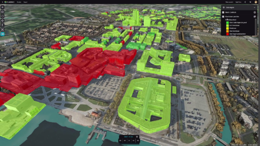
A true urban digital twin consists of multiple layers. The first is a digital replica – the digital city. Adding data from IoT creates the second – the connected city. Applying AI and simulations to that data produces the third – the intelligent city.

Niels van de Graaf

Digital Twin with a BLK2Go Handscanner

IMAGEM, in collaboration with Leica Geosystems, has made a solution available to integrate true-to-life and accurate images into a digital twin with the BLK2GO handheld scanner. We demonstrate it in the video below with scans of our office in Apeldoorn.

Tieme de Jonge

The Geospecial Podcast is live!

Podcasting. Everyone is doing it these days. And if you don’t, you listen to a podcast. And that’s not surprising, because there are so many interesting topics to listen to and talk about. But we were missing a podcast about the geoworld. So why not start one ourselves?

Data usefully insightful
how data is, will become, and stays relevant to you
learn more

We are IMAGEM.

We are curious and courageous in everything we do. Through dexterity and craftmanship, we connect space, time, and scale. We embrace change and dare to venture towards an ecosystem of innovation and co-creation that bridges the gap between the real world and the digital world.